← Home · Foundations

Pile Foundation Design in Des Moines: Geotechnical Data That Drives Decisions

Together, we solve the challenges of tomorrow.

LEARN MORE →

A common mistake we see in Des Moines is assuming that glacial till means uniform bearing. The reality is different: interbedded sand lenses, paleochannels filled with organic silt, and weathered shale at erratic depths create a profile where shallow footings fail differential settlement checks. When the geotech report calls for deep foundations, a generic pile design won't cut it. Our lab generates the site-specific parameters —skin friction, end bearing, lateral capacity— needed for a pile foundation design that accounts for the real stratigraphy under Polk County. The difference between a pile that holds and one that settles 2 inches often comes down to whether you tested the right layer.

Pile capacity in Des Moines glacial till depends more on pore pressure dissipation during driving than on the undrained shear strength alone.

How we work

Des Moines sits on Pennsylvanian-age bedrock overlain by Wisconsinan glacial drift —a mix of till, outwash, and loess— with groundwater typically found between 10 and 25 feet. This means pile foundation design in the metro area must handle both frictional resistance through stiff clay and end bearing on shale that weathers quickly when exposed to air. We run unconfined compression on shale cores and Atterberg limits on the till matrix to feed the axial capacity models. When the upper 20 feet show loose alluvium near the Des Moines River or Raccoon River floodplain, the design often shifts toward longer piles socketed into competent rock. For sites with suspect liquefiable layers, we pair our borings with liquefaction analysis to evaluate cyclic stress ratios per the NCEER methodology, and where granular soils dominate the upper profile, stone columns can be considered as a ground improvement alternative before pile installation.
Pile Foundation Design in Des Moines: Geotechnical Data That Drives Decisions
Technical reference image — Des Moines

Local considerations

Midwest freeze-thaw cycles are brutal on foundation elements. Des Moines sees air temperatures swing from -20°F in January to 100°F in July, and the upper 4 feet of soil undergo seasonal volume change that generates downdrag on pile shafts. We always compute the dragload per AASHTO LRFD Section 10.7 and check whether the structural section can take the combined axial load plus negative skin friction. Another local risk is the Raccoon River aquifer: pumping for the Water Works plant can lower the piezometric surface seasonally, altering effective stress around pile groups. Our designs include a sensitivity analysis on groundwater fluctuation so the pile foundation design doesn't rely on a single assumed water level that may not hold in August.

Need a geotechnical assessment?

Reply within 24h.

Email: contact@geotechnicalengineering1.org

Video resource

Typical values

ParameterTypical value
Design standardIBC 2021, Chapter 18 — Deep Foundations
Axial capacity methodFHWA GEC-12 (O'Neill & Reese, 1999) for drilled shafts
SPT energy correctionN60 per ASTM D4633, automatic trip hammer assumed
Driven pile analysisWEAP with CAPWAP signal matching on PDA data
Lateral analysisLPILE v2022, p-y curves from Reese & Van Impe (2000)
Shaft resistance in shaleα-method with α = 0.45 per Kulhawy & Phoon (1993)
Settlement checkt-z method, load-transfer curves per FHWA-NHI-10-016

Other technical services

01

Geotechnical Site Investigation for Deep Foundations

We mobilize a CME-75 truck rig across Polk and Dallas counties to execute SPT borings per ASTM D1586, with Shelby tube sampling in cohesive layers. Each boring log includes N60 values, pocket penetrometer readings on recovered shale, and groundwater observations at 24 hours. We deliver the factual report with stratigraphic profiles ready for the engineer's pile foundation design.

02

Laboratory Testing Program for Pile Capacity Parameters

From the Shelby tubes we run consolidated-undrained triaxial tests (ASTM D4767) on the till to get effective friction angle and cohesion intercept, plus one-dimensional consolidation (ASTM D2435) on any compressible silt seams. For the shale socket, we perform point load index testing (ASTM D5731) and slake durability (ASTM D4644) to assess degradation potential during construction.

Applicable standards

ASTM D1586-18 — Standard Penetration Test, ASTM D2487-17 — Unified Soil Classification System, IBC 2021, Chapter 18 — Deep Foundations, AASHTO LRFD Bridge Design Specs, 9th Ed. — Section 10, FHWA GEC-12 — Drilled Shafts: Construction Procedures and LRFD Design Methods

Questions and answers

How many borings are needed for a pile foundation design on a commercial building in Des Moines?

IBC Table 1803.1 requires a minimum of one boring per 2,500 square feet for structures with deep foundations, but we recommend spacing of no more than 100 feet between exploration points. A typical 20,000-square-foot footprint in downtown Des Moines will need at least 4 borings, with at least one extended to 20 feet below the anticipated pile tip elevation to check for weaker strata beneath the bearing layer.

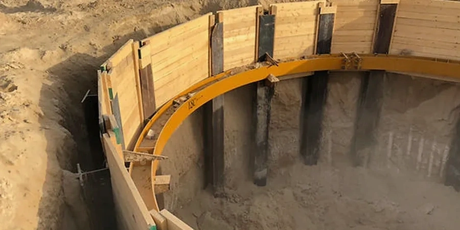
What is the typical pile type used in central Iowa?

Most projects in the Des Moines metro use drilled shafts (caissons) with diameters of 24 to 48 inches, socketed 3 to 5 feet into the Pennsylvanian shale. Driven H-piles are less common due to the refusal problems caused by boulders in the glacial till, though they appear on bridge projects along I-235 where the Iowa DOT has pre-approved pile load test data.

What does the pile foundation design service cost?

A complete pile foundation design package for a typical commercial building in Des Moines, including site investigation, laboratory testing, and the engineering calculations with sealed drawings, ranges from US$1,910 to US$6,510 depending on the number of piles, the complexity of the stratigraphy, and whether PDA testing is required during installation.

Location and service area

We serve projects across Des Moines and surrounding areas. More info.

View larger map